Can you rely on AIS for precise navigation?
The answer to this question is a clear NO. Many pilots do not realize this simple fact. I will by this throw some light on a matter I thought was common knowledge among most pilots:
Background
Automatic Identification System (AIS) transponder system is mandatory on ships in accordance to Regulation 19 of SOLAS Chapter V. This regulation came into force in 2002. AIS information like navigational and static data of your ship are transmitted in real-time over dedicated VHF frequencies providing this information to other ships, whereas AIS information from the other ships in the vicinity are received to be displayed on among others on the ECDIS of the ship.
The AIS system on the ship also comes with a standardized “AIS Pilot Plug”, where the ship pilot may connect in order to receive both VDO (Ship's Own) and VDM (other vessels’) messages. This AIS information is usually displayed on the pilot laptop that contains suitable Electronic Chard Display (ECD) software with updated charts.
AD Navigation of Norway provides a Pilot Plug Connector; the ADQ-2. This device is connected to the AIS Pilot Plug on the ship, and is transmitting the AIS data to the Pilots computer over WLAN. The ADQ-2 is also equipped with an independent Rate of Turn sensor to enhance the experience of the given data.

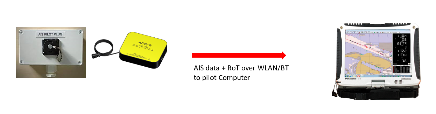
Fig1: Typical setup for a “lite” PPU system on a ship: ADQ-2 (or similar device) connects to the ship AIS Pilot Plug,
transmitting AIS targets and Own Ship Data over WLAN/Bluetooth to the Pilot Computer.
This particular setup is widely used throughout the world by active pilots who seek to find the best situational awareness and general information about the waters entered. What are then the challenges?
Pilot Plug not possible to properly validate
First, it is still a common problem that some ships have a malfunctioning pilot plug, so no data is available to the pilot in the first place. That is probably the least problem. Once connected, the data in your ECD system looks just nice, so what can then go wrong?
Some pilots do not fully realize that AIS is an information system, not a navigation tool. The AIS Pilot Plug on the ship was never designed to supply sensor data for the purpose of navigation and maneuvering in confined waters. The pilot has absolutely NO knowledge about the quality of the VDO (Ship’s Own) navigational messages that originates from the AIS system over the Pilot Plug. As an input for decisions, relying on those data can be very dangerous.
Some pilots do not fully realize that AIS is an information system, not a navigation tool.
Quality of GPS positioning is unknown
The Ship’s Own navigation messages contain among others information about the GPS position. However, the basis and quality of this GPS position is highly questionable:
- Is the Static Data that contains the GPS antenna location really correct?
- Is virtual GPS antenna positioning applied, and setting correctly applied?
- Are other settings in the AIS system affecting the GPS positioning entered correctly (chart datum, positioning and speed filtering/smoothing)?
The main point is that you do not know.
Typical sequences like docking, turning and bridge passing would also be risky, especially in case weather and/or light conditions are limiting the visual input for your cross checking. Some pilots are also relying on the AIS Pilot Plug for planning the meeting points in confined waters. Even if you have been able to verify that your own AIS information seems OK, the other vessel might be transmitting an incorrect GPS position.
The potential consequences go without saying.

Fig2: GPS error on the ship AIS. Maneuvering with the basis of such errors may potentially be very dangerous

Meeting points is easy going in good visibility....

What if the fog comes sneaking, and AIS is bad?
Furthermore, in case the pilot is tempted to make use of “vessel prediction” feature most Pilot software packages are offering, the predictions would potential be highly misleading when Virtual GPS Antenna Position is applied.
Gyro/Heading errors
Some suppliers of PPU Sensors are offering independent GPS receiver to compensate for the matters we have discussed in the last section. One concept is to combine this portable GPS with Pilot Plug Connector information. An alternative PPU approach is GPS with AIS receiver integrated in one box, and by this indirectly receive the Ship’s Own data via the transmitted AIS information in order to bypass the Pilot Plug. However, this is still insufficient. It is for unknown reasons more and more common that serious gyro errors are occurring, even on new ships with presumable the highest equipment standards. Fluctuating errors of 1-2 degrees are frequently observed by experienced pilots, and errors up to even 2.5 degrees have been reported.
So, what are the problems with the 2.5 degree heading error then?
PPU software packages are in real-time displaying the ship shape as a function of the GPS antenna reference position and heading. On a 250 m long vessel, the 2.5 degree heading error might potentially cause an error of the bow positioning up to 10 meters. For maneuvering purposes like tight turns, docking, lock approach, bridge passing etc., relying on AIS Pilot Plug data even in combination with the Pilots own GPS is dangerous business.

Fig3: Lock approach and predictions. Reliable predictions require reliable sensor input. Information from AIS Pilot Plug would be potentially unreliable for those challenging maneuvering purposes.
Conclusion
The information from AIS Pilot Plug is only suitable for Situational awareness and information purposes.
For maneuvering and docking the PPU systems 100% independent of ship systems is the only way to go.
Further reading
Download the Cap Blanche accident report. This grounding was caused by the incorrect use of AIS information.
Download the presentation by Capt Thom van der Hoff at EMPA 2015, related to the matters discussed above.